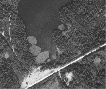
Floating Islands on Suneva Lake, near Nikiski, Alaska

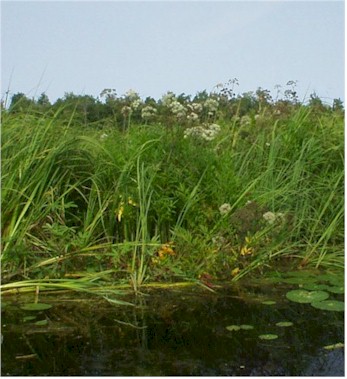
The vegetation on a floating island in Suneva Lake
Extent: 5 wetland polygons; 13.5 hectares; 0.01% of wetland area, 0.03% of wetland polygons.
Floating islands are literally islands floating on a few lakes of the Kenai Lowlands. They were formed when the outlet of a peatland was dammed by road construction. On the black & white aerial photo above, taken near Nikiski in 1996, the peatland was flooded forming Suneva Lake, leaving several vegetation mats floating on its surface. These islands are about a hectare (2.47 acres) in size, and one was observed drifting 1 kilometer over the course of three hours with a breeze of less than 5 mph.
A few floating islands, described in field notes, are dominated by water horsetail (Equisetum fluviatle) with western water hemlock (Cicuta douglasii) sometimes fringed with Sitka sedge (Carez aquatilis var. dives), and lesser amounts of beaked (C. utriculata), owlfruit (C. stipata) and smoothstem sedges (C. laeviculmis). The introduced weed, nodding beggartick (Bidens cernua), was encountered on one mat.
On Beluga Lake in Homer, a lake formed as a floatplane landing base by construction of a causeway, occasional small mats of bluejoint reedgrass calve from floating mats along the lake margin during high water events. These 25 square meter ‘islands’ float quickly with the wind, eventually lodging against the causeway (Lake Street), where they are removed.
Soils are not described, but are entirely organic. Based on a couple of nearby measurements, the mats are probably up to about 3 meters thick.
NWI and HGM
NWI would classify Kenai Lowlands floating islands as L1AB4Hh (permanently flooded diked or impounded Lacustrine Limnetic floating aquatic bed) when the island is floating over deeper lake water, or L2AB4Hh (permanently flooded diked or impounded Lacustrine Littoral floating aquatic bed) when the island is against the shore, or over water shallower than about 2 meters (6.6 feet).
In the HGM system, Floating Islands are classified as Lentic Island Floating mat throughflow wetland. Throughflow, because both Suneva and Beluga Lake have inlets and outlets.
Bluejoint floating mat is the only plant community documented for this ecosystem and is represented by a single plot:
| Summary of plant frequency and average cover for plants occurring on the single plot measured | |||||
| Wetland Indicator Status | |||||
| TAXON | f | % Cover | Alaska | National | |
| Calamagrostis canadensis | 1.0 | 75.0 | FAC | FAC, OBL | |
| Comarum palustre | 1.0 | 3.0 | OBL | OBL | |
| Carex laeviculmis | 1.0 | 1.0 | FACU* | UPL, FACU | |
| Carex magellanica | 1.0 | 1.0 | OBL | OBL | |
| Epilobium palustre | 1.0 | 0.5 | OBL | OBL | |
| Andromeda polifolia | 1.0 | 0.5 | OBL | OBL | |
| Menyanthes trifoliata | 1.0 | 0.5 | OBL | OBL | |
| Chamaedaphne calyculata | 1.0 | 0.5 | FAC | FAC | |


