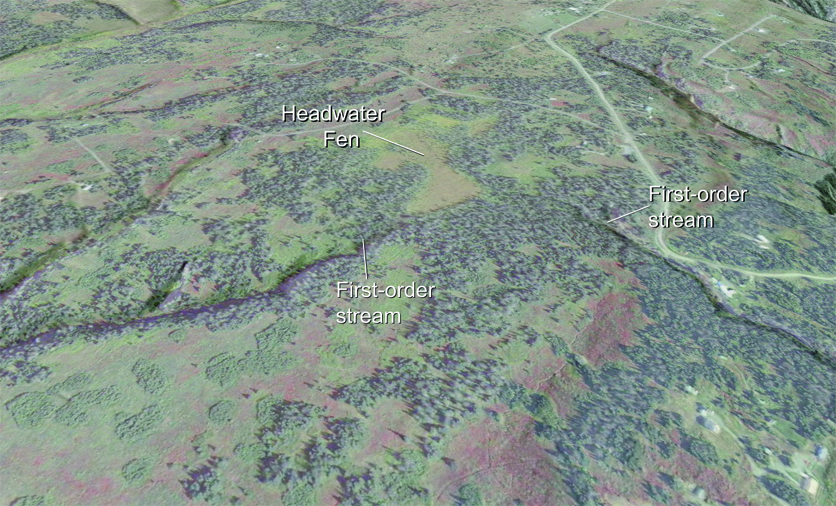
A shaded-relief satellite image showing a Headwater Fen straddling the divide between two first-order tributaries of the City of Homer’s drinking water supply.
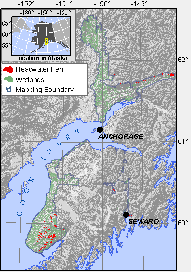
Range of wetlands mapped as Headwater Fens in Cook Inlet Basin.
Headwater Fens are peatlands formed in small cirques or at drainage divides at or near treeline at the headwaters of first-order streams. Headwater Fens often support diverse plant communities, especially in the Caribou Hills on the Kenai Peninsula, where many Headwater Fens are located.
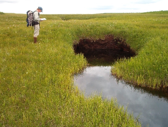
A stream emerging from beneath peat in a Headwater Fen at the headwaters of the Anchor River on the Kenai Peninsula.
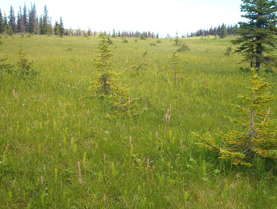
A diverse Headwater Fen supporting a healthy population of elephanthead lousewort (Pedicularis groenlandica), a rare plant in the State of Alaska, listed as S1S2 by the Alaska Natural Heritage Program.
Headwater fens may be a particularly important energy source at the center of stream food webs. Insects obtain part of their food from the micro-organisms that process carbon exported from Headwater Fens. Larger organisms, such as anadromous fish then feed on the insects (Peterson, et.al., 1986).
| Table 1. Wetland Indicators in Headwater Fen Geomorphic components throughout the Cook Inlet Basin. | ||||||||
| Map Component | Peat Depth (cm) | Water Table (cm) | Redox features (cm) | Saturation (cm) | pH | Alkalinity mg/l as CaCO3 | Specific Conductance µS/cm | Plant Prevalence Index |
H1 |
-5.0 (1) | 0 (1) | 6.3 (3) | 32.5 (3) | 83 (3) | 1.02 (1) | ||
H2 |
139 (14) | 5(12) | 0 (2) | 6.0 (3) | 36.0 (3) | 98 (2) | 1.62 (14) | |
H3 |
135 (18) | 11 (19) | 1 (2) | 4.8 (5) | 3.8 (5) | 28.8 (5) | 2.08 (16) | |
H4 |
13 (1) | 28 (1) | 20 (1) | |||||
Explanation:
- Numbers in paraentheses indicate number of samples.
- Peat depth is a minimum, because some sites had thicker peat deposits than the length of the auger used (between 160 – 493 cm).
- Water table depth is a one time measurement. At sites with seasonally variable water tables this measurement reflects both the conditions that year, and the time of year.
- Redox features with deep depths typically indicate deeper peat deposits, which mask redox indicators so the depth corresponds to the peat thickness.
- pH and specific conductance measured in surface water or a shallow pit with a YSI 63 meter calibrated each sample.
- Plant Prevalence Index calculated based on Alaska indicator status downloaded from the USDA PLANTS database, which may use different values than the 1988 list.
| Table 2. Common soils and plant communities found in Headwater Fens. | ||
| Map Component | COMMON SOILS | COMMON PLANT COMMUNITIES |
H2 |
STARICHKOF | Trichophorum caespitosum – Betula nana |
H3 |
STARICHKOF | Trichophorum caespitosum – Carex pauciflora
Empetrum nigrum – Vaccinium uliginosum |
H4 |
STARICHKOF | |
NWI and HGM
Headwater Fens fit into the US Fish and Wildlife Service’s National Wetland Inventory palustrine category. They are typically a combination of shrub-scrub and emergent palustrine systems (PSS/EM).
The LLWW hydrogeomorphic classification developed by Tiner (2003) classifies most Headwater Fens as Terrene Basin Outflow headwater wetlands. Where a Late Snow Plateau wetland is adjacent, the headwater fen would be a Terrene Basin groundwater-dominated Throughflow headwater wetland.
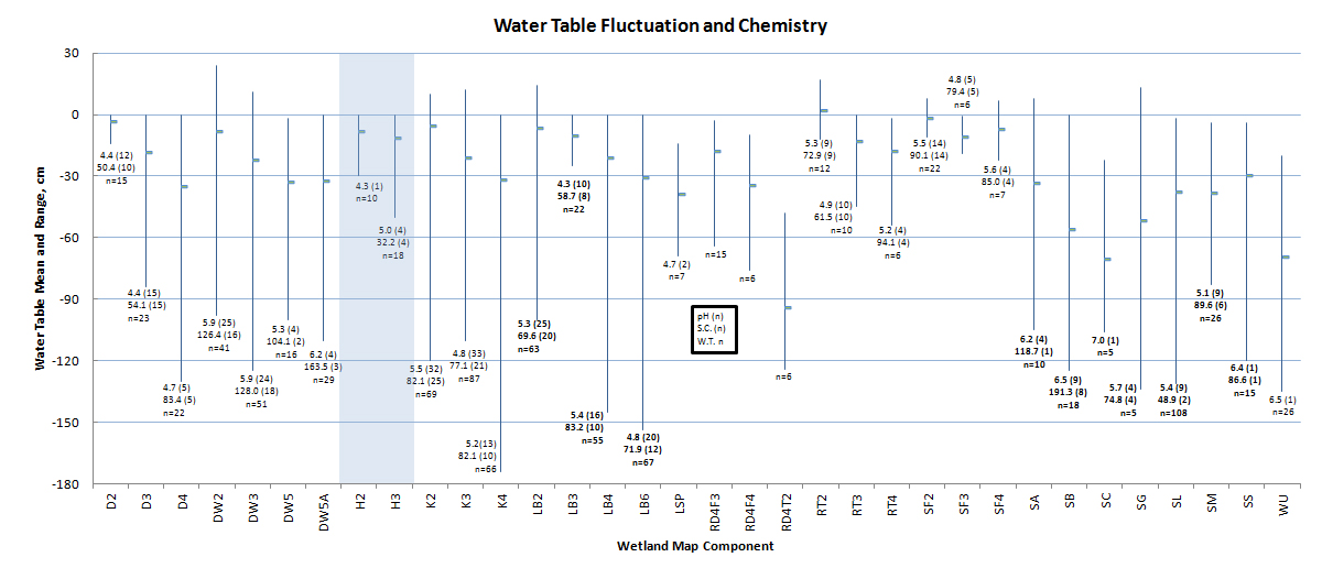
A comparison of water chemistry and the range of water table fluctuations of wetland mapping components in the Cook Inlet Basin. Headwater Fens (H2 and H3, highlighted in blue) have relatively stable water tables near the surface throughout the growing season. This is probably due to late snowmelt at the higher elevations where these wetlands are found. Specific conductance and pH are relatively low, reflecting the dominance of precipitation as a water source, and smaller input of groundwater to these high-elevation wetlands. D = Depression, K = Kettle; S = Discharge Slope; LB = Lakebed; SF = Spring Fen; RT = VLD Trough; R= Riparian; H = Headwater Fen; DW = Drainageway.
Cation Chemistry
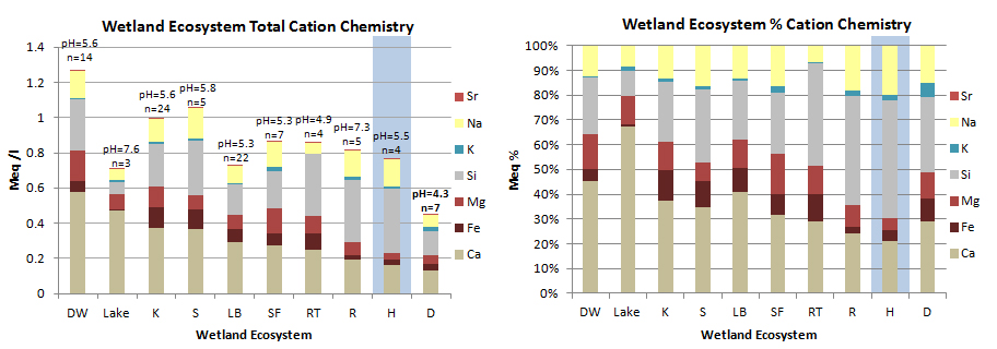
Cation chemistry by Geomorphic Component. Headwater Fens (highlighted in blue) have low cation concentrations compared to other Geomorphic Components, indicating a stronger precipitation influence on porewater chemistry. The high percentage concentration of sodium in Headwater fens (right-hand figure) may be due to higher inputs from oceanic sources at these higher elevation wetlands. Although calcium and silicon show the greatest concentrations, magnesium and iron concentrations in our area are high for natural waters. DW = Drainageway, K = Kettle; S = Discharge Slope; LB = Lakebed; SF = Spring Fen; RT = VLD Trough; R= Riparian; H = Headwater Fen; D = Depression.
Samples were collected from a surface pool where possible, otherwise from a separate shallow pit excavated to just below the water table. All samples were filtered through either a 0.2 micron filter using a disposable syringe, or pumped through a 0.45 micron filter using a peristaltic pump. Samples were acidified with ultra-pure nitric acid and kept cool until analysis on a direct current plasma spectrometer to about 5% accuracy (except K, 10-20% accuracy).
Headwater Fen Ecosystem Wetland Map Components:
H1: Ponds
- NWI: PEM
- HGM, LLWW: Terrene Basin groundwater-dominated Throughflow headwater. If not adjacent to a Late Snow Plateau Ecosystem wetland, then: Terrene Basin Outflow headwater.
H2: Headwater Fens with water table near the surface most of the growing season. Often dominated by sedges.
- NWI: PEM1Bg
- HGM, LLWW: Terrene Basin groundwater-dominated Throughflow headwater. If not adjacent to a Late Snow Plateau Ecosystem wetland, then: Terrene Basin Outflow headwater.
H3: Headwater Fens with fluctuating water table, often dominated by shrubs.
- NWI: PSS1,3&4Eg
- HGM, LLWW: Terrene Basin groundwater-dominated Throughflow headwater. If not adjacent to a Late Snow Plateau Ecosystem wetland, then: Terrene Basin Outflow headwater.
H4: Headwater fens with deeper, fluctuating water table, forested.
- NWI: PFO4Eg
- HGM, LLWW: Terrene Basin groundwater-dominated Throughflow headwater. If not adjacent to a Late Snow Plateau Ecosystem wetland, then: Terrene Basin Outflow headwater.
| Table 3. Summary of Headwater Fen Map Unit occurrence | ||
| Map Unit | N | Hectares |
| H1 | 10 | 8.1 |
| H12 | 1 | 30 |
| H13 | 2 | 4.1 |
| H1-3 | 26 | 111 |
| H2 | 45 | 175 |
| H21 | 14 | 68 |
| H23 | 37 | 165 |
| H2-4 | 7 | 30 |
| H3 | 80 | 187 |
| H31 | 1 | 0.2 |
| H32 | 40 | 193 |
| H34 | 28 | 101 |
| H4 | 32 | 102 |
| H42 | 1 | 0.7 |
| H43 | 17 | 61 |
